
This calculator determines the percentage of Earth's surface covered by a satellite at a given altitude \( H \) (in km) and angle of elevation \( \gamma \). Earth is modeled as a sphere with radius \( R = 6378 \) km. The covered area forms a spherical cap.
In the figure below, a satellite at point \( S \) in orbit around the Earth can only cover a portion of the Earth that has the shape of a spherical cap.
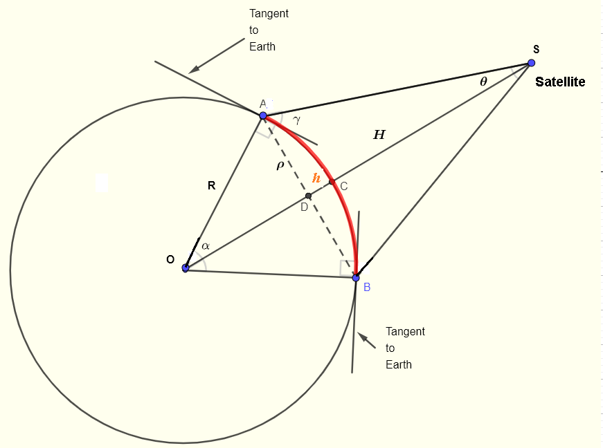
The figure below shows a two-dimensional representation of a satellite at an altitude \( H \) above the Earth's surface. \( \alpha \) is the half-angle at the center of the Earth between the vertical to the satellite and the radius to the horizon point. \( \gamma \) is the elevation angle of the satellite measured from the horizon.
The area of a spherical cap is given by:
\[ A_{cap} = 2\pi R h \]The ratio \( f \) of the cap area to the total Earth surface area is:
\[ f = \frac{2\pi R h}{4\pi R^2} = \frac{1}{2} \frac{h}{R} \]From the geometry, \( \cos(\alpha) = \dfrac{R-h}{R} = 1 - \dfrac{h}{R} \), therefore:
\[ \frac{h}{R} = 1 - \cos(\alpha) \]Substituting into the expression for \( f \):
\[ f = \frac{1}{2} (1 - \cos(\alpha)) \quad \text{(I)} \]From the triangle \( OAS \), the angles satisfy:
\[ \alpha + \gamma + \theta + 90^{\circ} = 180^{\circ} \implies \theta = 90^{\circ} - \alpha - \gamma \]Using the sine law in triangle \( OAS \):
\[ \frac{\sin(\gamma+90^{\circ})}{R+H} = \frac{\sin(\theta)}{R} \]Since \( \sin(\gamma+90^{\circ}) = \cos(\gamma) \) and \( \sin(\theta) = \sin(90^{\circ}-\alpha-\gamma) = \cos(\alpha+\gamma) \):
\[ \frac{\cos(\gamma)}{R+H} = \frac{\cos(\alpha+\gamma)}{R} \]Cross-multiplying:
\[ R \cos(\gamma) = (R+H) \cos(\alpha+\gamma) \]Therefore:
\[ \cos(\alpha+\gamma) = \frac{R}{R+H} \cos(\gamma) \]Taking the inverse cosine:
\[ \alpha + \gamma = \arccos\left(\frac{R}{R+H} \cos(\gamma)\right) \]Finally, solving for \( \alpha \):
\[ \alpha = \arccos\left(\frac{R}{R+H} \cos(\gamma)\right) - \gamma \quad \text{(III)} \]The calculator uses formulas (I) and (III) to compute the coverage percentage \( f \times 100\% \) and the half-angle \( \alpha \) at Earth's center.
Enter the altitude H and elevation angle γ to calculate the coverage percentage
| Satellite Type | Altitude H (km) | Elevation γ | Expected α | Calculated α | Expected Coverage f% | Calculated Coverage f% |
|---|---|---|---|---|---|---|
| Low Earth Orbit (LEO) | 500 | 0° | 20.1° | -- | 3.0% | -- |
| Low Earth Orbit (LEO) | 500 | 30° | 7.5° | -- | 0.4% | -- |
| Medium Earth Orbit (MEO) | 20,000 | 0° | 76.0° | -- | 37.9% | -- |
| Geostationary (GEO) | 35,786 | 0° | 81.3° | -- | 42.4% | -- |
| Geostationary (GEO) | 35,786 | 30° | 52.5° | -- | 19.6% | -- |
| Very High Orbit | 100,000 | 0° | 86.6° | -- | 47.0% | -- |
Note: The "Expected" values come from reference calculations using the same formulas. The "Calculated" columns show what this calculator produces. They should match closely!
Volume of a Spherical Cap
Sectors and Circles Problems
Circles, Sectors and Trigonometry Problems
Online Geometry Calculators and Solvers